Monday, July 11, 2005
GPS Coordinates of Flooding on Google Maps
Here is a link to Google Maps showing the intersection that has flooded after winds from Hurricane Dennis passed through.
The GPS coordinates are latitude 33.809212 and longitude -84.513756.
The flooded intersection appears within the photo centered at the top of the page. The street that runs left to right is darker (Roberts Drive) and the street that runs top to bottom is lighter (Brookside Drive).
The GPS coordinates are latitude 33.809212 and longitude -84.513756.
The flooded intersection appears within the photo centered at the top of the page. The street that runs left to right is darker (Roberts Drive) and the street that runs top to bottom is lighter (Brookside Drive).
Record Flooding in Johnston's Crossing subdivision
The Johnston's Crossing subdivision first residents moved in back in 1987. No one has ever seen as much flooding after a storm.

Posted by Picasa
Posted by Picasa
Potentially Dangerous Electrical Boxes Underwater
Two power boxes directly across the street from one another are almost submerged the morning after remnant weather from Hurricane Dennis passes through.
Posted by Picasa
Posted by Picasa
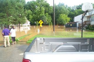
Neighbors Can Only Watch the Flooding
Neighbors observing the flooded one-way-in-one-way-out street in Johnston's Crossing subdivision. Neighbors were unable to go to work, school, and daycare.

Posted by Picasa
Posted by Picasa
Hurricane Dennis Leaves Record in Mableton, GA subdivision
The most significant flooding within the Johnston's Crossing subdivision's history in Mableton, GA USA

Posted by Picasa
Posted by Picasa
Street Flooding After Hurricane Dennis

![]()